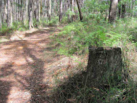


On Saturday afternoon February 20, 2010, I went over to the Olinda Forest, Dandenong Ranges National Park, 35 km east of Melbourne town.
My objective was to explore the Lyrebird Creek Gully and locate the Lyrebird Track.
I parked at the junction of Silvan Rd and gated Prices' Track, then proceeded into the forest, reaching the junction with Bridge Track. This track is unsigned and I descended it to the wooden bridge over the Lyrebird Creek.
Some maps show a Lyrebird Track leading off Bridge Track adjacent to the creek, but this was not found, apparently lost in undergrowth and ferns.
Lyrebird Creek was flowing, despite the drought.
I returned to Prices Track, to the junction with unsigned Chamberlain Track. An Emergency Marker has been installed here, designated DRN511.
I large puma came out of the forest to examine the marker, with a big tongue in a big cheek!
I followed Chamberlain Track, reaching Silvan Rd. This was a steep climb, from 296 m to 350 m.
From there, I returned to the car along Silvan Rd.
All this was about 4 km, passing through regrowth forest and fern gullies.
The area was heavily logged from the 1880s up to the 1960s, and was mostly destroyed by many fires in the years up to the late 1970s. Stumps and logs from the timber cutting area are seen along the tracks. The tracks were formerly used for transporting logs out of the forest by bullock wagons, and are now used for fire management purposes and by hikers, horseriders, and cyclists.
See all of the Photos of my visit!

No comments:
Post a Comment