Rotating Headlines from this Weblog! Click to view Post!

Rotating Headlines

Join this Weblog!

To become a Follower of this Weblog.
Click on the "Follow" link, underneath the list of current followers. You will be taken to an information panel where you may enter your personal details and other information. When completed, the title of this Weblog will appear in the Reading List on your Blogger Dashboard, and your Profile Picture will be displayed next to other Followers!

Followers to my Weblog!

Showing posts with label myrtleford. Show all posts

Monday, December 18, 2017

Myrtleford - Reform Hill


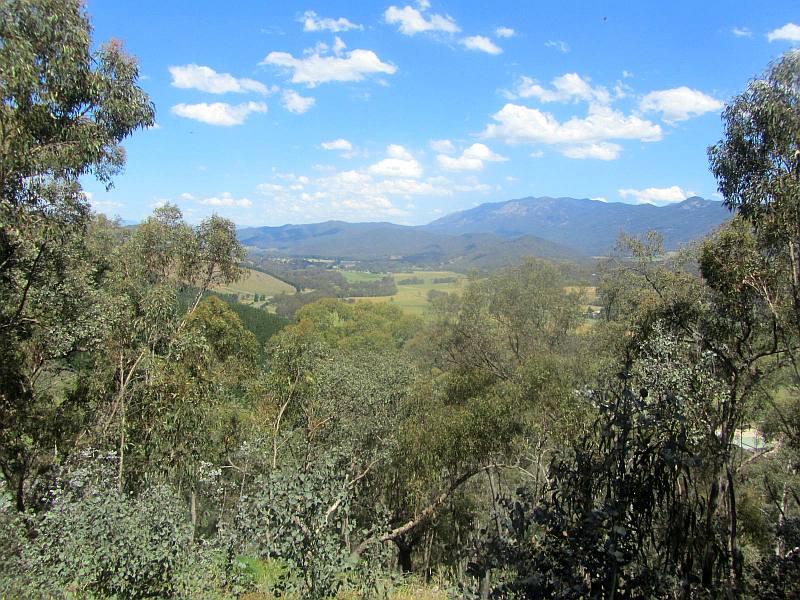
These photos show the scenery and environment from the Reforn Hill Lookout, on December 15, 2017. The Lookout is reached either from the main walking trail on the Great Alpine Rd in Mytleford, or by road,  This is quaintly named "Scenic Rd". They should rename it "Lookout Rd". There are no buses to the Lookout!

As we had previously done the walking route on two earlier trips, this time we went by road! Part of the road route is quite steep, rough, dusty, stony and twisty. They should set up winches. Or have a horse and buggy. Or build a  chairlift, a zipline network, or a rack railway.
 
The actual lookout platform is a ten-minute walk up from the car park, with some steps near  the top, where nice views appear across the Alps and over Mytleford They should construct a telescope there. Or advise visitors to bring their own. A stone cairn shows directions and distances to various remote mountains, some obscured by nearby trees. There are two wooden seats at the lookout, seemingly from the Goldrush era. They are full of spiders and ants - local students could be employed to do a stain and varnish job, including the inhabitants.

A geodetic marker is nearby.  It  could do with a clean and polish. Or put some advertising on it. There is also an Info Board at the car park. The info on it seems to have been produced in the 19 century. Somebody needs to attend to that. A large colored sign says "Reform Hill" but is partly hidden by a tree. Relocate the sign, or tree, or both. Reform needed!

Next go the geodetic marker, a sign says "Revegetation Area". Seems odd, as it is on bare earth, nothing to revegetate there. Students could b organized to xdo some plantings.
 
The signpost on the Scenic Road is badly positioned and needs painting. It's at the junction of two tracks. We took the wrong track and ended up in nowhere land next to old pine plantations - we were not really equipped for cutting down pine trees for Christmas . They should have a Christmas Tree stall up there. Proceeds to go to the Knuckleheads Progress Association.

Our Subaru Forester All Wheel Drive became heavier on the way down due to the weight of the dust collected. Many tonnes.  The Shire should get a water tanker to remove the dust. Or put a tap at the summit.

Smile!


Tuesday, August 10, 2010

Ascent of Reform Hill, Myrtleford


This article is an account of our visit to the Reform Hill, Myrtleford, 300 km NE of Melbourne, on Saturday August 7, 2010.

Reform Hill takes its name from a rich Gold Bearing Quartz Reef discovered in 1854. Trial crushings yielded a high proportion of gold, ten ounces to the ton. The gold bearing quartz was in places 7 metres wide and ran through the core of the hill.

This reef brought about the development of Myrtleford due to the long term nature of quartz reef gold mining and the area's location on a fertile valley. John Riley was allotted 100 yards of reef which became known as the Reform and from there the mine grew rapidly.

To crush the quartz stone, the Reform Battery was erected on the Banks of the Happy Valley Creek opposite the mine tunnel entrance, very near where the Old Butter Factory is today. The battery was powered by a water wheel about 5 metres in diameter and treated the stone of the district at a cost of 33 shillings per ton. It could crush about 19 tons of quartz per day, 24 hours per day, 6 days a week.

For over 30 years the Reform Mine was a principal employer within Myrtleford, with the miners paid around 2 pounds and 10 shillings a week, (about $5) in the mid 1880's. The mine closed in 1888 due mainly to a large amount of water entering the shafts. It is estimated that the mine produced around 21,500 ounces of gold, which at todays prices, would be worth around 20 mllion Dollars.

Starting at Jone's Reserve, on the Great Alpine Rd, Mick and I climbed the Hill to the Lookout, starting at Jone's Reserve on the Great Alpine Rd, crossing the Rail Trail, then via the Gully Track, and returned via the Spur Track, about 3 km in all.

Features of this walk were the monument to Hume and Hovell, built in 1924 to celebrate their exploration in 1824, the the old reservoir, nice stands of Grass Trees, and the old (covered) ventilation shaft of the Reform Mine.

The Lookout is a cleared area with a Trig Point Marker and it can also be reached by car up a steep management road. There are spectacular views towards the Mt Buffalo Massif, the Victorian Alps, over the Myrtleford town, and west along the Ovens Valley.

We saw some eastern Grey Kangaroos and Rock Wallabies!

The bushland is known as the Reform Hill State Forest and is now mainly regrowth, as the original forest was cleared during the gold days for fuel and building materials.

The Battery was resited to its present location some years ago - the historical display includes an information board with photos.

See all of the Photos of our visit!

Friday, August 01, 2008

Huggin's Lookout - Bright


Huggin's Lookout, altitude 487 m, overlooks the town of Bright, 335 km NE of Melbourne.

It is reached from the town centre along Baker's Gully Rd, then McFadyer's Rd, and along unsealed Huggin's Rd, a forest management road passing through plantations and crown land, starting near the town centre, or by a walking-track which starts near the Stadium. Huggin's Rd continues down the valley, ultimately reaching the town.

The views from the Lookout are superb, looking across Bright and the surrounding hills.

I drove up to this Lookout on July 28, 2008, with friend Mick, with whom I was staying for a few days in Bright at his new country home.

On July 29, 2008, I did a 3 km hike up an interesting foot-track near the Lookout, through bushland, with nice views across Bright to the hills beyond, passing a mob of kangaroos which were grazing in a nearby paddock!

See the full set of Photos