Rotating Headlines from this Weblog! Click to view Post!

Rotating Headlines

Join this Weblog!

To become a Follower of this Weblog.
Click on the "Follow" link, underneath the list of current followers. You will be taken to an information panel where you may enter your personal details and other information. When completed, the title of this Weblog will appear in the Reading List on your Blogger Dashboard, and your Profile Picture will be displayed next to other Followers!

Followers to my Weblog!

Showing posts with label warburton. Show all posts

Tuesday, May 13, 2014

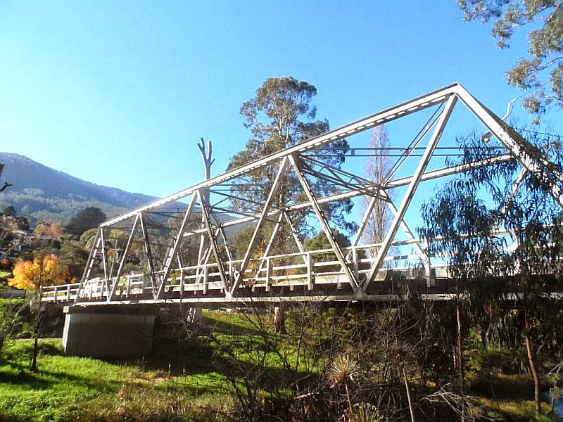
Warburton in late Autumn


Pix of my 3 km hike in Warburton May 13 2014.

This was from the site of the former Warburton Station, along the La La Railway Extension (built in 1909) to the location of the sidings (clo
sed with the Railway in 1964).


Boinga Bob's House is nearby!


Then back along the Yarra River Walk, passing the Brisbane Bridge, and a look at the Water Wheel next to the Info Centre.

The station platform has been partially preserved, and a beautiful collection of large colored paintings is on display there, showing historic scenes of Warburton.
 

Good views on a sunny day in late-autumn!


Click here to see all of the Photos of my visit, in Slideshow or Static format!

Tuesday, January 29, 2013

Centenary of the O'Shannassy Water Supply System - 1913 to 2013 - a Pictorial Heritage


Centenary of the O'Shannassy Water Supply System - 1913 to 2013 - a Pictorial Heritage
 

This comprehensive and fascinating on-line, free Research Study, authored by
Bob Padula, OAM, of Melbourne, Australia, describes, in words, sound, maps,
diagrams, and images, the history of the O'Shannassy Aqueduct Water Supply
System, commissioned in 1914, which was Melbourne's major water supply
system.

Published in January 2013, it commemorate the occasion of the Centenary
of the System, many elements of which remain in operation today
 

It contains 32 Chapters, and examines the planning, design, construction, development, and operations of the Aqueduct, the Weir, the Reservoir, and the Silvan Dam, which represented a massive engineering construction project of the time.

The Aqueduct itself was decommissioned in 1997, and the Study includes
information about the transition and evolution of alternative underground
forms of water delivery into Melbourne from the O'Shannassy Catchment.

A special inclusion is a Virtual Tour along the full length of the O'Shannassy Aqueduct Trail, where readers may experience many Points of Interest along the route.


T
he Mt. Evelyn Aqueduct, the Yarra Valley Conduit, and the Yarra Silvan Conduit are included.

Many of the images have never been published previously in the public
domain.

The author draws heavily on his passion for bushwalking and outdoors photography, and his numerous and extensive visits to the region since 1952.

The work is licensed under a Creative Commons Attribution-NoDerivs 3.0
Unported License.

The author is a Chartered Professional Engineer, and enjoys Life Membership
of the Institution of Engineers Australia, holding the rank of MIE (Aust.)

The Study is dedicated to the men and women who were involved in the
planning, design, construction, maintenance, and operations of the System.

The Study may be viewed at:

http://bpadula.tripod.com/oshannassy

Wednesday, August 08, 2012

Dee Slip Bridge - O'Shannassy Aqueduct Trail


These pix were taken on August 4, 2012.

They show the scenery, environment and features along the Dee Bridge Sector of the O'Shannassy Aqueduct Trail, Warburton, 70 km east of Melbourne.


My 4 km return hike started at the Dee Rd car park and picnic area, crossing the Harrison Creek, then easterly to the Dee Slip Bridge and beyond.


East of the Dee Rd junction is the Dee Slip Bridge. This was restored during 2008, and is the only timber trestle bridge on the system. It was built in 1947 following the collapse of the aqueduct. The force of the flow created a large hole in the side of the embankment beneath the aqueduct, and two separate trestle bridges now support the maintenance track and the aqueduct at this point. A section of the aqueduct immediately adjacent to the bridge collapsed again in 1991, the repairs to the channel are visible.


The replacement channel was fabricated from steel.

It is not commonly known, but the picnic ground and car park occupy an area on which a timber tramway once operated. This tramway carried logs cut down from the area extending from just above the car park and the slopes of Ben Cairn higher up.


It ran from the top of Dee Rd, passing over the Harrison Creek. A rough foot-track starts from the car park and extends into the forest past the Creek. There is little evidence remaining of the original timber cutting, except for some blackened stumps from the 1939 Black Friday bushfires which ravaged this part of the forest.

The tramway transported logs to the mill operated by Kennedy and Munro in the years 1885-1886, which was located below the present-day Aqueduct on the east side of the Dee River. From there, the sawn timber was carried on the Dee Valley Tramway to the railhead at Millgrove.

The Dee Valley Tramway started at Mortimer Brothers' Mill (1903-1910) near the summit of Ben Cairn, and carried timber from various mills.

A mill operated by McKechnie was located just past the end of present day Dee Rd. This operated for some 50 years, from 1919 to 1968, and was on land which is now private freehold property.

See the complete set of Photos of my visit!

Friday, July 27, 2012

O'Shannassy Aqueduct Trail - Rocky Creek Sector


These pix were taken on July 24 2012 on the O'Shannassy Aqueduct Trail, Warburton, 70 km east of Melbourne.

This was a 4 km return hike along the Yuonga Rd to Mt Donna Buang Rd sector.

This sector crosses the Rocky Creek Gully and Cascades. In the years 1900 to 1920 the Gully was a popular destination for visitors coming from Warburton by foot, horse, or by buggy. In the years to 1912, the Gully was accessible from the Mt Donna Buang Bridle Track, which became the Mt Donna Buang Tourist Rd in 1912.

Nowadays, the Gully may be explored by a rough track from the top which starts at the Aqueduct Trail - access from the bottom is no longer possible. The creek is obscured by dense undergrowth, fallen trees and ferns.

Rocky Creek has its headwaters high up near the Mt Donna Buang Summit, and after passing under the Mt Donna Buang Rd it continues downwards to a further crossing under the Woods Point Rd, then into the Yarra River.

When the Aqueduct was built in the 1911-1914 years, it was decided to run a pipe under the Aqueduct and not allow it flow into the Aqueduct. This arrangement was due to the relatively high year-round flow of the Creek.

In 1906, a channel carried water from the Creek to the Adventist Church "Signs" publishing establishment, which was located at the bottom of present-day Yuonga Rd.

Some early-1900s photos of Rocky Creek have been included in this Album!

See the Slideshow of my visit!

Exploring Mt Donna Buang on a sunny winter 's day


These pix were taken on July 23 2012 at Mt Donna Buang, 80 km east of Melbourne.

They show the scenery and environment along the Mt Donna Buang Tourist Rd, which links the township of Warburton with the Summit, altitude 1280 m, a distance of 26 km.


My visit was to inspect points of interest in support of my forthcoming on-line Heritage Research Project "The Early Sawmills of the Warburton Forests"


Two Lookouts are passed on the ascent, offering spectacular views of the Yarra Valley and Warburton, far below.


These Lookouts are sited near the tops of logging inclines of the 1920s.

See the complete Slides Show of my visit!

Sunday, July 22, 2012

O'Shannassy Aqueduct Trail - Sussex St Sector


These pix were taken on July 20 2012, on a 4 km return hike on the Sussex St section of the O'Shannassy Aqueduct Trail, 70 km east of Melbourne, at Warburton.


The Sussex St entry point is reached by following Surrey Rd from near the Mayer Bridge over the Yarra, which links the Warburton Highway with Damman's Rd.

This Section of the Trail is of historical interest, passing concrete bridges once used for timber tramways for Horden's Sawmill (1932-1937, Richard's Sawmill (1907-1913)and Parbury's/Anderson's Brookfield Sawmill (1901 to 1928).

The trail also crosses the Ythan Creek.


Just off the trail is a short walking track to the Ythan Creek, to a weir, and the adjacent Warburton Reservoir.

Further to the east, the Trail crosses the Mt Victoria Walking Track.


A fire/comms tower is located next to reservoir, adjacent to Sussex St.

Past the Mt Victoria Walking Track another logging tramway bridge is encountered - this was for Richard's Mill, (1907 to 1913) which was located about 1 km north of the Aqueduct. The tramway started at the former Richard's Bridge on the Yarra, which was replaced many years later by the present day Brisbane Bridge.

The legacy of Richard remains as Richard's Rd, which runs off Brisbane Hill Rd.


The Aqueduct was built between 1911 and 1914, and the open channel sections were heightened in 1925/1926. It was decommissioned in 1997. The Maintenance Track is now a 27 km shared trail.

Seer the complete set of Photos of my visit!

Monday, July 09, 2012

O'Shannassy Aqueduct Trail - west of Yuonga Rd

View from the Trail


These pix were taken on July 7 2012 on the O'Shannassy Aqueduct Trail, Warburton, 65 km east of Melbourne.

They show the scenery, features, and environment on a 5 km (return) hike, from the Yuonga Rd access car park, to the Mt Victoria Walking Track crossing.

Start of Mt Victoria Walking Track
The Aqueduct was built in the years 1911 to 1915, and was abandoned in 1997.

The Yuonga Walking Track starts at the end of Yuonga Rd, which heads north from the car park.

Bridge across former logging tramway site

The Yuonga Track is heavily overgrown, with fallen trees, and extends to the Mt Donna Buang Tourist Rd, but is now impassable. This Track follows the alignment of the original timber tramway which linked the Wonwondah Sawmill to the forests of Mt Donna Buang and Mt Victoria.

Mechanisms to control overflow gates

Two of the Aqueduct's original concrete bridges are passed on this section of the Trail, which were crossing points for the former timber tramways. These serviced the La La and Richard's sawmills in the early 1900s to the 1920s.

Approaching Yuonga Rd
 RdSee the complete set of Photos of my visit!

Wednesday, July 04, 2012

Big Pat 's Creek - Upper Yarra Walking Track


These pix were taken on July 3 2012.

They show the scenery and features along the northern section of the Upper Yarra Walking Track, known as the "Walk into History", at Big Pat's Creek, 80 km east of Melbourne, past the town of Warburton.


The Track follows the alignment of the old Federal logging tramway which linked the settlement of Big Pat's Creek with the former timber mills in the Big Pat's Creek gully, ending at Starling Gap, some 8 km to the south.


My visit started at the Bridge at Big Pats Creek, then south to the small picnic area on the Creek. I returned along Smythe Creek Rd, about 4 km total


About half way along the track, a few metres of iron rails and points remain, which for reasons unknown were never removed when the tramway was dismantled in the 1950s. These were part of the "Point frog", at the junction of the Starvation Creek and Federal tramways.

See all of the Photos of my visit!

Sunday, July 01, 2012

O'Shannassy Aqueduct Trail - Pickersgill Section


These pix were taken on June 29 2012 along the Pickersgill section of the O'Shannassy Aqueduct Trail, East Warburton.

This section of the Trail is reached from the access gate of the Mt Donna Buang Rd.


The Pickersgill family owned a large tract of land in the early 1900s, extending from what is now the Wood's Point Rd in the south, to the present day Mt Donna Buang Rd, then a bridle track.

Robinson's Sawmill No. 1 was located on this property, adjacent to the Rocky Creek, and operated between 1911 and 1922.


Logs from the Mt Donna Buang and Mt Victoria regions entered the Mill via a timber tramway, which ran down the steep slopes, crossing the Mt Donna Buang bridle track, now the Mt Donna Buang Rd, then over the O'Shannassy Aqueduct and on to the Pickersgill property.


The original stone bridge over the Aqueduct survives, but no trace of the tramway exists.

A sign displaying the name "Pickersgills" is visible on the top of the aqueduct wall.

See all of the Photos of my visit!

Warburton Rainforest Skywalk Gallery


These pix were taken on June 30, 2012, at the Warburton Rainforest Skywalk and Gallery, 10 km from Warburton.


It's at the junction of the Donna Buang Rd and Acheron Way.


This beautiful site 
is at the junction of the Donna Buang Rd and Acheron Way, and features a 40 metre long observation platform (one of only three of its type in Australia) which takes you into the rainforest canopy 15 metres above the ground.

A 350 metre long elevated walkway takes you through the Rainforest Gallery where you will see magnificent 65 metre tall old growth Mountain Ash trees, ancient Myrtle Beech trees (many of which are 300 to 400 years old), ferns, mosses and other plants that make up this damp and diverse rainforest environment.

There are several viewing spots along the walkway where you can pause and enjoy the sounds of Cement Creek flowing past on its journey to the Yarra River.


The observation platform is 40 metres long and has no steps. It has a level floor surface consisting of steel grating suitable for wheelchairs and strollers. Handrails and safety fencing are on the sides of the platform.

See an animated Slideshow with sound, of my visit!

Sunday, June 17, 2012

O'Shannassy Aqueduct Trail - Warburton - Yuonga Rd to Mt Donna Buang Rd section


These pix were taken on June 16 2012, on a 3 km (return) hike along the O'Shannassy Aqueduct Trail,  from the Yuonga Rd carpark to the Mt Donna Buang Rd.


See the Slideshow of all of the photos, with music, of my visit!