To become a Followerof this Weblog. Click on the "Follow"link, underneath the list of current followers. You will be taken to an information panel where you may enter your personal details and other information. When completed, the title of this Weblog will appear in the Reading Liston your Blogger Dashboard, and your Profile Picture will be displayed next to other Followers!
These pix were taken on Sunday December 16 2012 along the Southern Section of the Maroondah Aqueduct Trail, in the district of Research, 20 km NE of central Melbourne.
They show the scenery, features, and environment on a 3 km (return) hike from the trail access point at Ingram's Rd, to the southern end of the Trail on Main Rd.
The Trail follows the open section of the old Aqueduct.
The Maroondah Aqueduct, 66 km long, was built in 1892 and carried water from the Maroondah Weir to the Preston Dam, decommissioned in 1978 when it was replaced by underground pipes.
The former management track between Main Rd (Eltham North) and Allendale Rd (Research) is now a shared trail for cyclists, pedestrians and hounds, about 4 km one way.
The Maroondah Aqueduct, 66 km long was built in 1892 and carried
water from the Maroondah Weir to the Preston Dam, decommissioned in
1978 when it was replaced by underground pipes.
The former management
track between Main Rd (Eltham North) and Allendale Rd (Research) is now a
shared trail for cyclists, pedestrians and hounds, about 4 km.
I
explored some 6 km (return) of the Trail on Nov 20 2012, starting at the
Ingram’s Rd crossing.
These pix were taken on November 17 2012 and show the scenery, features, and environment on a 5 km (return) hike along the Diamond Creek Trail, Eltham, in Melbourne's outer east.
My visit started at the main entrance of the Edendale Community Environmnent Farm, following the Diamond Creek, passing the Eltham North Reserve, soccer fields, cricket ovals, barbecues, the wetlands, to the turnaround point at Allendale Rd
The Farm site was originally part of a 20 hectare property first purchased from the crown in 1852 by pioneer Henry Stooke. Stooke was a prominent citizen in the Eltham district. He was actively involved in the development of infrastructure and recreational services in the Eltham area.
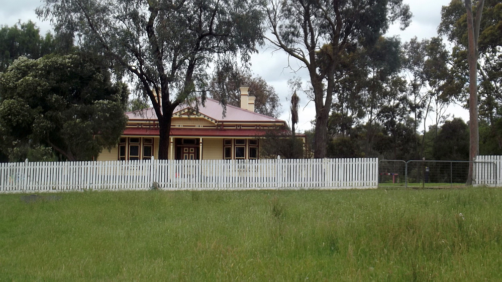
The subsequent owner was Thomas Cool, manager of the Victorian Coffee Palace, which adjoined the Town Hall in Collins Street, Melbourne. Cool purchased the site in 1896, and built the homestead in the same year. This weatherboard homestead was unusual in the level of finishings and decoration compared with other farmhouses of the district.
History of property ownership (from 1922):
1922 - Thomas Cool sold the property to John William Cox
1933 - John William Cox sold the property to the Gaston Family
1968 - Elizabeth Gaston sold the property to Douglas Mummery
1970 - Douglas Mummery sold the property to the Shire of Eltham
The Shire of Eltham purchased the property in 1970 establishing an animal pound and small nursery. Council came to realise the potential of the site in the early 1980s when the decision was made to relocate the animal pound. During the late 1980s a number of changes were made to the site to establish the area as a Community Farm for local residents.
Since 2000, the direction of the site has been transformed into a Community Environmental Education Centre featuring an Indigenous Plant Nursery. The heritage homestead has been beautifully restored using funding from Heritage Victoria, the Federal Government and Council. The next stage of development includes the reconstruction of the heritage homestead gardens.
In 2011, following the construction of three new buildings and the restoration of the heritage homestead, Living and Learning Nillumbik began to run nationally recognized Children’s Services courses from Edendale. Other training courses are also run by Living and Learning Nillumbik in other Edendale buildings.
See a Slideshow of all of the Photos of my visit! Information about Edendale is at
Sweeneys Flats is a relatively large preserved woodland park, on the north bank of the Yarra River, Eltham, about 30 km NE of Melbourne.
It is reached from Mt Pleasant Rd (Eltham), then into Sweeney's Lane. A car park and access gate are at the end of this road.
Members of the Wurundjeri tribe of Aboriginals originally inhabited the area. The area remains significant to descendants of the Wurundjeri. During the 1840s, the land around Sweeneys Flats was purchased by Thomas Sweeney, a former convict who established an extensive property built by hard work and initiative. The Hawthorn hedge that remains is still a small part of what was once a system of many hedgerows separating the paddocks of the property from one another.
Directly opposite, on the south bank of the river, is the Tikalara Park, Candlebark Park, and Main Yarra Trail.
The pictures were taken on Monday afternoon Februry 6, 2012, showing the views, river scenes, lagoon, former hedges, and ducks, along the interesting 4 km (return) walking trail, which ends at the Griffith Bushland Park.
The river has several sections and exposed rock formations which are popular for swimming, paddling, and fishing during the warmer months.
See the full set of Photos of my visit, and check out my YouTube video!
Sweeneys Flats is a relatively large preserved woodland park, on the north bank of the Yarra River, Eltham, about 30 km NE of Melbourne.
It is reached from Mt Pleasant Rd (Eltham), then into Sweeney's Lane. A car park and access gate are at the end of this road.
Members of the Wurundjeri tribe of Aboriginals originally inhabited the area. The area remains significant to descendants of the Wurundjeri. During the 1840s, the land around Sweeneys Flats was purchased by Thomas Sweeney, a former convict who established an extensive property built by hard work and initiative. The Hawthorn hedge that remains is still a small part of what was once a system of many hedgerows separating the paddocks of the property from one another.
Directly opposite, on the south bank of the river, is the Tikalara Park, Candlebark Park, and Main Yarra Trail.
See all of the Photos of my visit, taken on Wednesday afternoon July 7, 2010, showing the views, river scenes, dry lagoon, former hedges, the 1800s Homestead, and ducks, along the interesting 4 km (return) walking trail, which ends at the Griffith Bushland Park.